
USPS Shipping Zones: Explained


USPS Shipping Zones: Explained

Since January 2019, USPS has used Zone-Based Pricing for all mail classes. However, for many, the USPS Shipping Zones have been a source of much confusion. But knowing how these zones work, matters. It helps you estimate shipping costs for your eCommerce store and plan an effective shipping strategy. So, in this post, we’ve de-mystified the USPS Zones and made them easy to understand. And we’ve answered your burning questions, such as:
Contents:
- What are the USPS Shipping Zones?
- How do I figure out which zone I'm shipping to?
- How do USPS Zones impact my shipping costs?
- Why is it important to understand how the zones work?
- How do I know what zone I’m in?
- What is USPS Zone 1 and 2?
Ready to become a USPS Zone expert? Let’s go… 👇
What are the USPS Shipping Zones?
The USPS Shipping Zones are often mistaken as being defined by geographical locations. For example, someone may think Atalanta, Georgia is Zone 5. However, zones are actually based on the distance the item travels from its origin point (in miles).
Let’s say you’re a business owner in Chicago shipping clothes to a customer in Denver. This would be Zone 5 because Denver is within a 601-1000 mile radius of Chicago. But if you sent an item from Chicago to Austin, this would also be Zone 5, as it falls within the same radius. So, Zone 5 will always be a location within 601-1000 miles of your business, rather than 1 physical place.
To make it even easier to grasp, we’ve included a breakdown of all the USPS Shipping Zones below…
The USPS Shipping Zones
- Zone 1: Locations within a 50 mile radius of your business
- Zone 2: Locations within a 51-150 mile radius of your business
- Zone 3: Locations within a 151-300 mile radius of your business
- Zone 4: Locations within a 301-600 mile radius of your business
- Zone 5: Locations within a 601-1000 mile radius of your business
- Zone 6: Locations within a 1001-1400 mile radius of your business
- Zone 7: Locations within a 1401-1800 mile radius of your business
- Zone 8: Locations within a 1801 mile radius or farther from your business
- Zone 9: Locations within freely associated states
As you can see, there are 9 zones. Zones 1-8 are used for Domestic US locations. Whereas Zone 9 is for outlying territories such as Guam, the US Virgin Islands, Puerto Rico, and American Samoa.
How to Figure Out USPS Zones with the Domestic Zone Chart
The best (and easiest) way to figure out what zone you’re sending a package to is by using USPS’ Domestic Zone Chart. Here’s a 3-step guide on how to use the chart and work out your zone...
Step 1:

Select “Get Zone for Zip Code Pair”.
Step 2:
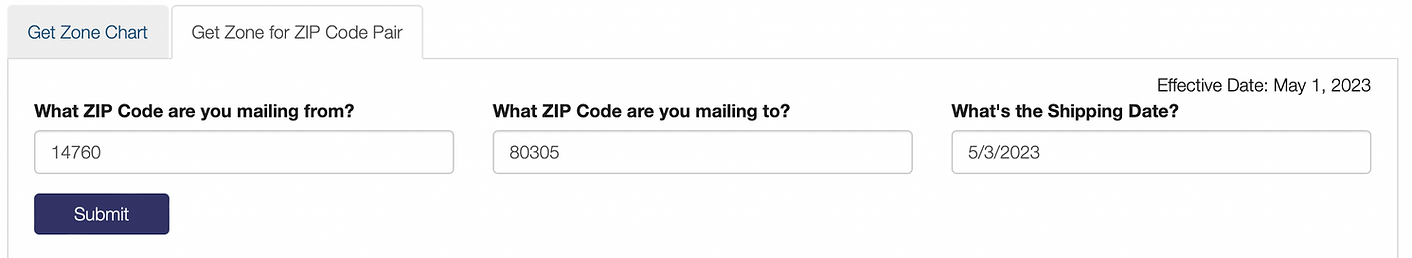
Type in the ZIP Code you're sending your package from (we’ve used our New York business address). Then, type in the ZIP Code you’re mailing to (we selected a ZIP Code in Boulder, Colorado). After that, type in your shipping date.
Step 3:
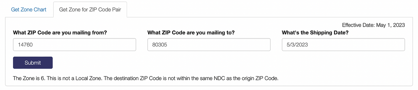
Voila, you should now know the zone you’re shipping to! As you can see, our package from New York to Colorado is Zone 6. It really is as easy as that.
How USPS Zones Impact Your Shipping Cost
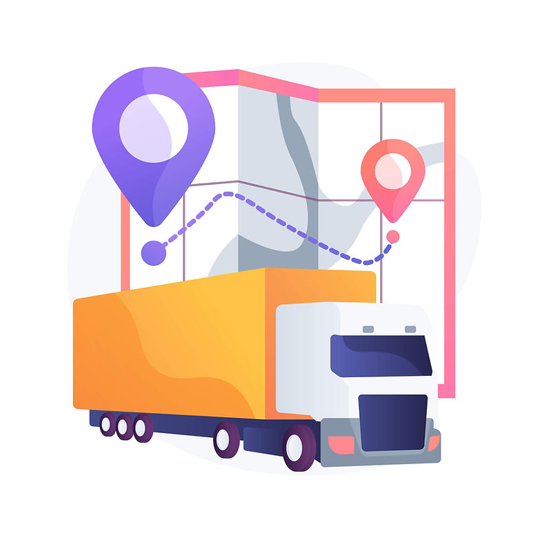
Image by vectorjuice on Freepik
There are 3 different factors that impact the cost of USPS shipping rates:
- The USPS service you choose. I.e. The more expedited the service, the more costly it is to ship.
- The size & weight of an item(s). The exception to this is when you use flat-rate shipping. In this instance, size, weight, and distance don’t factor into your costs.
- Distance. And this cost is defined by, you guessed it - the USPS Shipping Zones!
Here’s some simple math...
The higher the USPS Zone number = the further location is away from your Zip Code.
The further you ship away from your location = the higher the cost of shipping.
So, if you’re shipping to Zone 1, that’s going to be the least expensive zone to ship to. Because it’s the closest to your business. Whereas Zone 8 would be the most expensive zone in the US, because it’s furthest away. And if you’re sending a package to Zone 9 (outlying US territories), it’s going to be even more costly.
However, if you’re regularly shipping to higher zones, there is a way to reduce distance-based costs. Flat-rate shipping. With USPS flat-rate, weight and USPS Zones (distance) do not affect rates. A single rate is given for all zones.
To add to that, you can save even more money on USPS labels with shipping software. Users at Ship.com are able to access up to 84% off USPS Retail Rates! Plus, the platform automatically finds the cheapest cost for your shipments. As a result, you don’t have to do all the searching and working out. You can simply let the software show you the best prices and biggest discounts.
Did you know? In 2022, Ship.com saved small business owners $1.9 million. And the platform has over 350 five ⭐ reviews on Trustpilot. Buyers cite ease-of-use, amazing USPS & UPS discounts, and awesome customer service as the reason why.
Conclusion - Knowing Your Zones = Accurate Cost Estimates and a More Efficient Shipping Strategy
So, let’s sum up! One of the key factors that impacts shipping cost is the distance your package travels. The longer the distance, the higher the cost. USPS Shipping Zones help you determine shipping cost based on distance. Therefore, by knowing how USPS Zones work, you can more accurately estimate the cost of shipping your products. Plus, that’ll help you effectively plan your shipping strategy.
FAQ’s:
How do I know what USPS Zone I am in?
USPS Zones aren’t actually physical locations. Instead, each zone describes how far the recipient's location is from where you’re sending a package. For example - if you’re shipping an item, Zone 1 would be a location within 50 miles of your business, Zone 2 would be within 50-100 miles, and so on. The higher the zone number, the further it is from your location (the point of origin).
What is Zone 1 and 2 for USPS?
Zones 1 and 2 aren’t literal geographical locations. Zone 1 is used to describe a location within 50 miles of where a package is sent from (point of origin). Whereas Zone 2 is a location within 50-100 miles of the point of origin.
Try Ship.com for Free. No Credit Card Required.
Recent blogs
Browse our recent posts to stay up-to-date with the latest ecommerce tips, strategies, and insights shared by industry experts and successful entrepreneurs.


